One card per weather maker, all laid out the same way, so you can put a cold front next to a warm front and see the difference — then a recall table and six questions to apply it. Every line on the cards comes from the FAA’s current Aviation Weather Handbook. Where the cited section says nothing, the card says “Not specified” — this booklet does not fill gaps from memory.
A front is a boundary or transition zone between two air masses. Cold and warm fronts are classified by which air mass is replacing the other.
At the surface, a front is usually detectable three ways: a significant temperature difference across it, winds that usually converge on it, and pressure that typically falls as it approaches and rises after it passes.
A front is not vertical: it slopes over the colder, denser air.
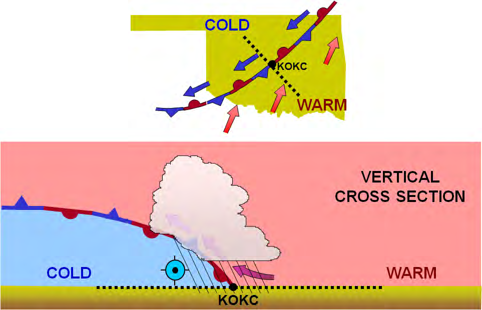
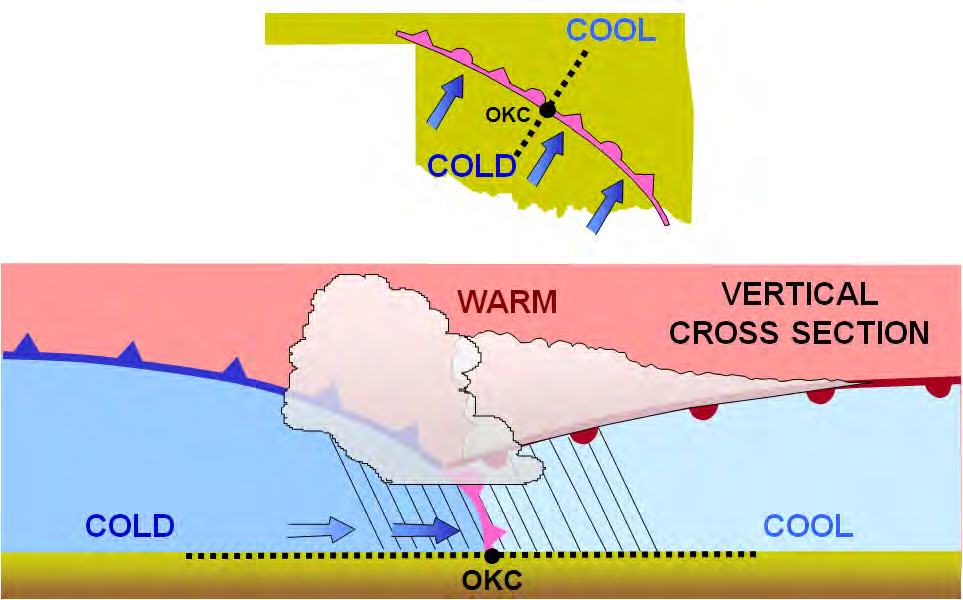
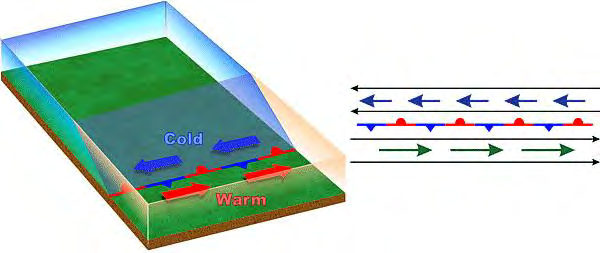
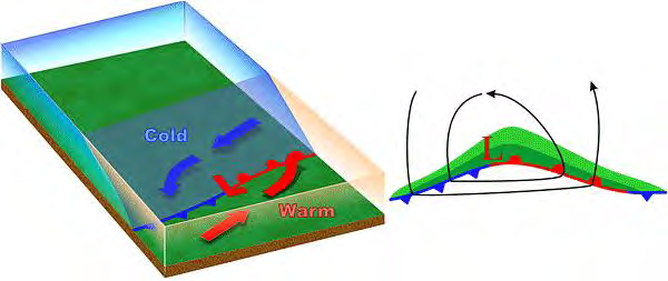
On the surface chart
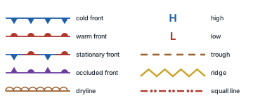
Redrawn from FAA-H-8083-28B, Figure 27-25
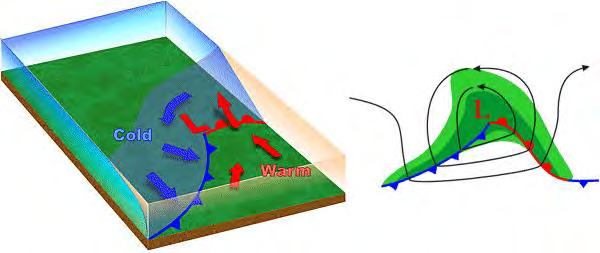
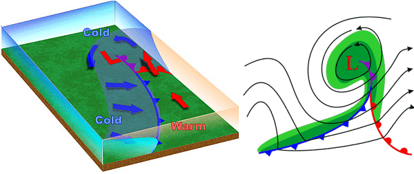
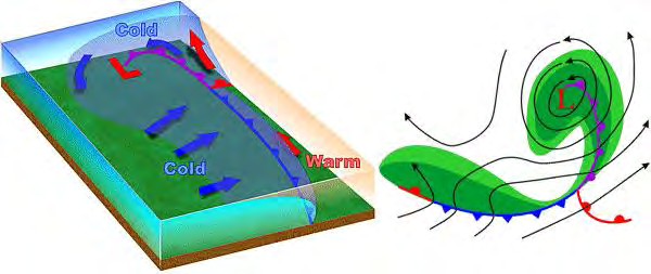
On a surface chart, the symbols on a front show its type and point the way it is moving.
Stationary or occluded?TECHNIQUE Both alternate triangles and half-circles. On a stationary front they sit on OPPOSITE sides of the line, in two colours; on an occluded front, on the SAME side, in one colour. The handbook shows this in its drawings (Figures 11-4 and 27-25), not in its text.
Not specifiedNot specified means the cited handbook section does not give that detail. It never means no weather or no hazard.
Typical is not guaranteedTECHNIQUE
The handbook describes its fronts in hedged words — typically, usually, may, if the warm rising air is unstable. Read every card with those words still attached: a card says what to look for, not what will happen. Brief the actual weather before you fly.
Every front card follows the same order: what it is, a figure, and its key numbers. Then the cold and warm cards show before, during and after; the stationary and occluded cards show what to expect, because the handbook gives no before/during/after passage breakdown for them. Every card ends with its pilot hazards (any exception first) and one source line.
Source: AWH 11.3, pp. 11-4, 11-5 · 25.2.2.1.3, p. 25-6 · chart symbols redrawn from Figure 27-25
The handbook’s own words
“A front is a boundary or transition zone between two air masses.” AWH 11.3, p. 11-4
“Fronts are classified by which type of air mass (cold or warm) is replacing the other” AWH 11.3, p. 11-4
“Fronts are usually detectable at the surface in a number of ways: significant temperature gradients, or differences, exist along fronts (especially on the cold air side)” AWH 11.3, p. 11-5
“winds usually converge, or come together, at fronts” AWH 11.3, p. 11-5
“pressure typically decreases as a front approaches and increases after it passes” AWH 11.3, p. 11-5
“they have a vertical structure in which the front slopes over the colder (denser) air mass” AWH 11.3, p. 11-5
“For surface analysis charts, positions and types of fronts are shown by symbols” AWH 25.2.2.1.3, p. 25-6
“The symbols on the front indicate the type of front and point in the direction toward which the front is moving.” AWH 25.2.2.1.3, p. 25-6
2 · Air masses
ACS PA.I.C.K3e
FAA GUIDANCE
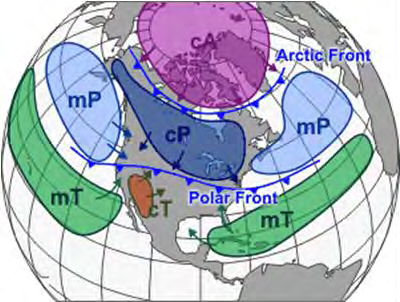
FAA-H-8083-28B, Figure 11-1 (cropped)
An air mass forms over a source region. The longer it stays there, the more likely it is to acquire the properties of the surface below.
Read the code: small letter = moisture, capital letter = temperature.
Continental (c) — over land, dry
Maritime (m) — over water, moist
Arctic (A)Extremely deep and cold; forms mostly in winter over ice and snow.
cAContinental ArcticCold, dry.
mAThere is no maritime Arctic (mA) on the list: it seldom, if ever, forms.
Polar (P)Relatively shallow, cool to cold; forms over high latitudes.
cPContinental PolarCold, dry.
mPMaritime PolarCool, moist.
Tropical (T)Warm to hot; forms over low latitudes.
cTContinental TropicalHot, dry.
mTMaritime TropicalWarm, moist.
How an air mass changes as it moves
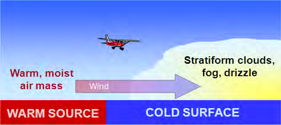
Warm, moist air moving over a cold surface becomes stable: stratiform clouds, fog and drizzle.
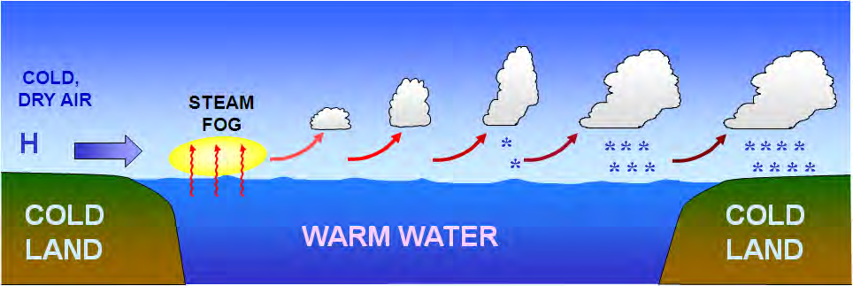
Lake effect: in autumn and winter, cold, dry, stable polar air flowing over relatively warm lake water is heated and moistened, and stability decreases. Cumuliform clouds and showers often develop in bands over, and to the lee of, large, ice-free lakes.
Air masses change as they travel: in winter, an arctic air mass can move over the ocean, picking up some warmth and moisture and becoming a maritime polar (mP) air mass.
Source: AWH 11.2, 11.2.1, 11.2.1.1, 11.2.1.2, 11.2.1.3, p. 11-2 · 11.2.2, p. 11-3 · 11.2.2.1, p. 11-4 · Figures 11-1, 11-2, 11-3
The handbook’s own words
“The area from which an air mass originates is called a source region.” AWH 11.2, p. 11-2
“The longer the air mass stays over its source region, the more likely it will acquire the properties of the surface below.” AWH 11.2, p. 11-2
“Air masses are classified according to the temperature and moisture properties of their source regions” AWH 11.2.1, p. 11-2
“Arctic (A)—An extremely deep, cold air mass” AWH 11.2.1, p. 11-2
“Continental (c)—A dry air mass that develops over land.” AWH 11.2.1, p. 11-2
“An extremely deep, cold air mass that develops mostly in winter over arctic surfaces of ice and snow.” AWH 11.2.1.1, p. 11-2
“A relatively shallow, cool to cold air mass that develops over high latitudes.” AWH 11.2.1.1, p. 11-2
“A warm to hot air mass that develops over low latitudes.” AWH 11.2.1.1, p. 11-2
“A dry air mass that develops over land.” AWH 11.2.1.2, p. 11-2
“A moist air mass that develops over water.” AWH 11.2.1.2, p. 11-2
“Continental Arctic (cA)—Cold, dry.” AWH 11.2.1.3, p. 11-2
“Continental Polar (cP)—Cold, dry.” AWH 11.2.1.3, p. 11-2
“Continental Tropical (cT)—Hot, dry.” AWH 11.2.1.3, p. 11-2
“Maritime Polar (mP)—Cool, moist.” AWH 11.2.1.3, p. 11-2
“Maritime Tropical (mT)—Warm, moist.” AWH 11.2.1.3, p. 11-2
“Maritime Arctic (mA) is not listed, since it seldom (if ever) forms.” AWH 11.2.1.3, p. 11-2
“A warm, moist air mass moving over a cold surface (see Figure 11-2) produces stable air associated with stratiform clouds, fog, and drizzle.” AWH 11.2.2, p. 11-3
“Lake effect is the effect of any lake in modifying the weather near its shore and for some distance downwind.” AWH 11.2.2.1, p. 11-4
“As initially cold, dry, stable polar air over land flows over the relatively warm water, the air is heated and moistened, and stability decreases.” AWH 11.2.2.1, p. 11-4
“In autumn and winter, cumuliform clouds and showers often develop in bands over, and to the lee of, large, ice-free lakes” AWH 11.2.2.1, p. 11-4
“For example, in winter, an arctic air mass (very cold and dry air) can move over the ocean, picking up some warmth and moisture from the warmer ocean and becoming a maritime polar (mP) air mass” AWH 11.2.2, p. 11-3
3 · Pressure systems
ACS PA.I.C.K3b
FAA GUIDANCE
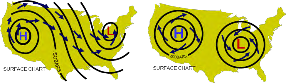
Highs, lows, troughs, ridges and the isobars between them.
FAA-H-8083-28B, Figure 10-11
High
Low
Trough
Ridge
What it is
A maximum of pressure: closed isobars on a surface chart. Also called an anticyclone.
A minimum of pressure: closed isobars on a surface chart. Also called a cyclone.
An elongated area of relatively low pressure.
An elongated area of relatively high pressure.
Surface wind
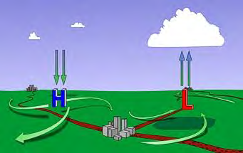
Northern Hemisphere: surface wind spirals clockwise and outward.
Northern Hemisphere: surface wind spirals counterclockwise and inward.
Winds converge around surface troughs.
Not specified
Weather
At the surface: winds diverge, so air sinks, compresses and warms, which favors the dissipation of clouds and precipitation.
At the surface: winds converge, so air rises, expands and cools, which favors the formation of clouds and precipitation given sufficient moisture.
Typically associated with clouds and precipitation.
Typically associated with fair weather, except in winter when valley fog may occur.
Reading the isobars
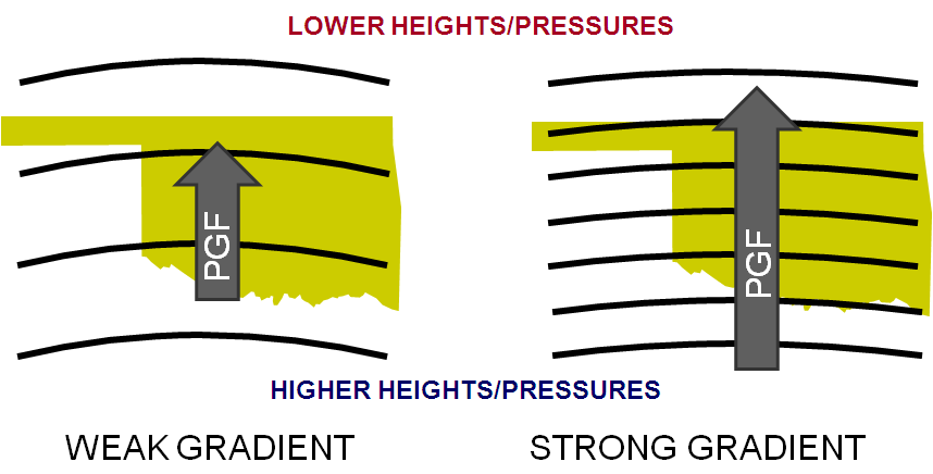
Read wind speed from isobar spacing: closely spaced means strong wind, widely spaced means lighter wind.
Surface wind does not follow the isobars. Friction slows the wind, so Coriolis force weakens and the stronger pressure gradient force turns the wind across the isobars toward lower pressure: about 10° over water, as much as 45° over rugged terrain.
Source: AWH Table 25-2, p. 25-7 · 10.5, p. 10-7 · 12.4.2, p. 12-6 · 22.2, p. 22-2 · 25.3.1.1, p. 25-20 · 10.3.1, p. 10-2 · Figures 10-11, 12-5, 10-2
The handbook’s own words
“A maximum of atmospheric pressure in two dimensions (closed isobars) on a surface chart, or a maximum of height (closed” AWH Table 25-2, p. 25-7
“contours) on a constant-pressure chart. Also known as an anticyclone.” AWH Table 25-2, p. 25-7
“in the Northern Hemisphere, the surface wind spirals clockwise and outward from high pressure and counterclockwise and inward into low pressure” AWH 10.5, p. 10-7
“winds diverge away from surface high pressure, causing the air to sink, compress, and warm, which favors the dissipation of clouds and precipitation” AWH 12.4.2, p. 12-6
“A minimum of atmospheric pressure in two dimensions (closed” AWH Table 25-2, p. 25-7
“isobars) on a surface chart, or a minimum of height (closed contours) on a constant-pressure chart. Also known as a cyclone.” AWH Table 25-2, p. 25-7
“winds converge into surface low pressure, causing the air to rise, expand, and cool, which favors the formation of clouds and precipitation given sufficient moisture” AWH 12.4.2, p. 12-6
“An elongated area of relatively low atmospheric pressure or height.” AWH Table 25-2, p. 25-7
“Lifting mechanisms include converging winds around surface lows and troughs” AWH 22.2, p. 22-2
“Typically, lows and troughs are associated with clouds and precipitation, while highs and ridges are associated with fair weather, except in winter when valley fog may occur.” AWH 25.3.1.1, p. 25-20
“An elongated area of relatively high atmospheric pressure” AWH Table 25-2, p. 25-7
“Closely spaced contours/isobars indicate strong winds, while widely spaced contours/isobars mean lighter wind.” AWH 10.3.1, p. 10-2
“As frictional force slows the wind speed, Coriolis force decreases. However, friction does not affect PGF.” AWH 10.5, p. 10-7
“The stronger PGF turns the wind at an angle across the isobars toward lower pressure until the three forces balance” AWH 10.5, p. 10-7
“The angle of surface wind to isobars is about 10° over water, increasing to as high as 45° over rugged terrain.” AWH 10.5, p. 10-7
4 · Cold front
ACS PA.I.C.K3e
FAA GUIDANCE
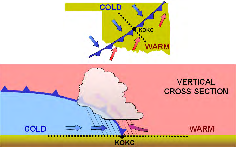
Cold, dense, stable air advances and replaces warmer air, sliding under it like a snowplow.
Speed:
25–30 mph; extreme fronts up to 60 mph.
Slope:
Steep. Warm air is forced upward abruptly.
Where the weather sits:
A narrow band along, or just ahead of, the front, if the warm rising air is unstable.
FAA-H-8083-28B, Figure 11-6
Before
During
After
Clouds and precipitation
Cirriform or towering cumulus; cumulonimbus may develop. Rain showers may develop.
Towering cumulus or cumulonimbus dominate the sky. Depending on the intensity of the front: heavy rain showers, which may be accompanied by lightning, thunder and/or hail.
Towering cumulus and cumulonimbus dissipate to cumulus. Precipitation decreases.
Visibility and wind
Not specified
Poor visibility. Variable, gusty wind.
Good visibility, eventually. Wind typically from the west-northwest.
Temperature and dewpoint
High dewpoint.
Temperature and dewpoint drop rapidly.
Remains cooler.
Pressure
Falling.
Bottoms out, then begins a gradual increase.
Continues to rise.
Pilot hazards — and the exception
ExceptionIf the warm air being overtaken is relatively stable, overcast skies and rain may continue for some distance behind the front.
A squall line, a continuous line of thunderstorms, may form along or ahead of the front. Squall-line storms are intense and move quickly.
Heavy rain showers at passage, which may be accompanied by lightning, thunder and/or hail. More severe cold fronts can also produce tornadoes.
Behind a fast-moving front the skies usually clear rapidly, but it leaves behind gusty, turbulent winds and colder temperatures.
Source: AWH 11.3.2, p. 11-6 · Figure 11-6
The handbook’s own words
“A cold front occurs when a mass of cold, dense, and stable air advances and replaces a body of warmer air.” AWH 11.3.2, p. 11-6
“acts like a snowplow, sliding under the warmer air and forcing the less dense air aloft” AWH 11.3.2, p. 11-6
“progressing at a rate of 25 to 30 mph” AWH 11.3.2, p. 11-6
“moving at speeds of up to 60 mph” AWH 11.3.2, p. 11-6
“Cold fronts have a steep slope, and the warm air is forced upward abruptly” AWH 11.3.2, p. 11-6
“This often leads to a narrow band of showers and thunderstorms along, or just ahead of, the front if the warm rising air is unstable.” AWH 11.3.2, p. 11-6
“Prior to the passage of a typical cold front, cirriform or towering cumulus clouds are present, and cumulonimbus clouds may develop.” AWH 11.3.2, p. 11-6
“Rain showers may also develop due to the rapid development of clouds.” AWH 11.3.2, p. 11-6
“A high dewpoint and falling barometric pressure are indicative of an imminent cold front passage.” AWH 11.3.2, p. 11-6
“As the cold front passes, towering cumulus or cumulonimbus clouds continue to dominate the sky.” AWH 11.3.2, p. 11-6
“Depending on the intensity of the cold front, heavy rain showers form and may be accompanied by lightning, thunder, and/or hail” AWH 11.3.2, p. 11-6
“During cold front passage, the visibility is poor with winds variable and gusty, and the temperature and dewpoint drop rapidly.” AWH 11.3.2, p. 11-6
“A quickly falling barometric pressure bottoms out during frontal passage, and then begins a gradual increase.” AWH 11.3.2, p. 11-6
“After frontal passage, the towering cumulus and cumulonimbus clouds begin to dissipate to cumulus clouds with a corresponding decrease in the precipitation.” AWH 11.3.2, p. 11-6
“Good visibility eventually prevails with the winds from the west-northwest.” AWH 11.3.2, p. 11-6
“Temperatures remain cooler and the barometric pressure continues to rise.” AWH 11.3.2, p. 11-6
“If the warm air being overtaken by the cold front is relatively stable, overcast skies and rain may occur for some distance behind the front.” AWH 11.3.2, p. 11-6
“A continuous line of thunderstorms, or squall line, may form along or ahead of the front.” AWH 11.3.2, p. 11-6
“Squall lines present a serious hazard to pilots as squall-type thunderstorms are intense and move quickly.” AWH 11.3.2, p. 11-6
“More severe cold fronts can also produce tornadoes.” AWH 11.3.2, p. 11-6
“Behind a fast-moving cold front, the skies usually clear rapidly, and the front leaves behind gusty, turbulent winds and colder temperatures.” AWH 11.3.2, p. 11-6
5 · Warm front
ACS PA.I.C.K3e
FAA GUIDANCE
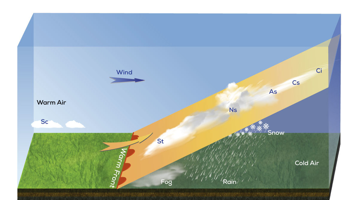
Warm air advances and replaces colder air, sliding up over the top of it.
Speed:
Slow: typically 10–25 mph.
Slope:
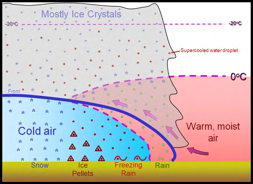
Typically gentle. Warm air rises gradually along it.
Where the weather sits:
Widespread, along and ahead of the front, if the warm rising air is stable.
“Cross section through a warm front (cropped)” by Kh1604, Wikimedia Commons (a crop of Kh1604’s “Cross section through a cold front and warm front”), CC BY-SA 4.0 (creativecommons.org/licenses/by-sa/4.0). Km scale and distance bar removed by RunupLab; this cropped version is licensed CC BY-SA 4.0. · Source page · Licence: CC BY-SA 4.0
Reading the pictureTECHNIQUE Schematic, not to scale.
Before
During
After
Clouds and precipitation
Cirriform or stratiform clouds, with fog; cumulonimbus likely in summer. Light to moderate rain, sleet, snow or drizzle.
Stratiform clouds. Drizzle may be falling.
Stratocumulus predominate. Rain showers possible.
Visibility and wind
Poor visibility. Wind typically from the south-southeast.
Visibility generally poor, but improving. Variable wind.
Visibility improves eventually; may stay hazy for a short period. Wind typically from the south-southwest.
Temperature and dewpoint
Cool or cold; dewpoint increasing.
Rises steadily; dewpoint mostly steady.
Warming; dewpoint rises, then levels off.
Pressure
Falls until the front passes.
Levels off.
A slight rise, then a decrease.
Pilot hazards — and the exception
ExceptionIn summer, thunderstorms are likely.
Poor visibility in light to moderate precipitation ahead of the front.
Fog along the frontal boundary before passage.
Source: AWH 11.3.1, p. 11-5 · Figure: Kh1604, Wikimedia Commons, CC BY-SA 4.0
The handbook’s own words
“A warm front occurs when a warm mass of air advances and replaces a body of colder air.” AWH 11.3.1, p. 11-5
“The slope of the advancing front slides over the top of the cooler air and gradually pushes it out of the area.” AWH 11.3.1, p. 11-5
“move slowly, typically 10 to 25 mph” AWH 11.3.1, p. 11-5
“Warm fronts typically have a gentle slope, so the warm air rising along the frontal surface is gradual” AWH 11.3.1, p. 11-5
“This favors the development of widespread layered or stratiform cloudiness and precipitation along, and ahead of, the front if the warm rising air is stable.” AWH 11.3.1, p. 11-5
“Generally, prior to the passage of a warm front, cirriform or stratiform clouds, along with fog, can be expected to form along the frontal boundary.” AWH 11.3.1, p. 11-5
“In the summer months, cumulonimbus clouds (thunderstorms) are likely to develop.” AWH 11.3.1, p. 11-5
“Light to moderate precipitation is probable, usually in the form of rain, sleet, snow, or drizzle, accentuated by poor visibility.” AWH 11.3.1, p. 11-5
“The wind blows from the south-southeast, and the outside temperature is cool or cold with an increasing dewpoint.” AWH 11.3.1, p. 11-5
“the barometric pressure continues to fall until the front passes completely” AWH 11.3.1, p. 11-5
“During the passage of a warm front, stratiform clouds are visible, and drizzle may be falling.” AWH 11.3.1, p. 11-5
“The visibility is generally poor but improves with variable winds.” AWH 11.3.1, p. 11-5
“The temperature rises steadily from the inflow of relatively warmer air.” AWH 11.3.1, p. 11-5
“For the most part, the dewpoint remains steady and the pressure levels off.” AWH 11.3.1, p. 11-5
“passage of a warm front, stratocumulus clouds predominate, and rain showers are possible.” AWH 11.3.1, p. 11-5
“The visibility eventually improves, but hazy conditions may exist for a short period after passage.” AWH 11.3.1, p. 11-5
“The wind blows from the south-southwest.” AWH 11.3.1, p. 11-5
“With warming temperatures, the dewpoint rises and then levels off.” AWH 11.3.1, p. 11-5
“There is generally a slight rise in barometric pressure, followed by a decrease of barometric pressure.” AWH 11.3.1, p. 11-5
6 · Stationary front
ACS PA.I.C.K3e
FAA GUIDANCE
Two air masses of roughly equal force: the boundary between them stays put.
Speed:
Stationary.
Slope:
Can vary.
Where the weather sits:
In the warm rising air along the front.
FAA-H-8083-28B, Figure 11-7
What to expect
It influences the local weather for days.
Clouds and precipitation still form in the warm air rising along the front.
The weather is typically a mixture of what both warm and cold fronts bring.
Pilot hazards
Not itemized in AWH 11.3.3 — this is not a statement that no hazards exist.
Source: AWH 11.3.3, p. 11-7 · Figure 11-7
The handbook’s own words
“When the forces of two air masses are relatively equal, the boundary or front that separates them remains stationary and influences the local weather for days.” AWH 11.3.3, p. 11-7
“Stationary frontal slope can vary, but clouds and precipitation would still form in the warm rising air along the front” AWH 11.3.3, p. 11-7
“remains stationary and influences the local weather for days” AWH 11.3.3, p. 11-7
“The weather associated with a stationary front is typically a mixture that can be found in both warm and cold fronts.” AWH 11.3.3, p. 11-7
7 · Occluded front
ACS PA.I.C.K3e
FAA GUIDANCE
Cold fronts typically move faster than warm fronts, so in time they catch up to a warm front and the two merge.
Speed:
Not specified
Slope:
Not specified
Where the weather sits:
Clouds and precipitation can occur along, ahead of, and behind the surface front.
FAA-H-8083-28B, Figure 11-8
What to expect
At the front, the cold air undercuts the retreating cooler air mass of the warm front, further lifting the already rising warm air.
As it approaches: warm-front weather, immediately followed by cold-front weather.
Cold front occlusion: the cold front is colder than the air ahead of the warm front. Cold air replaces cool air and forces the warm front aloft. Typically a mixture of warm-front and cold-front weather, providing the air is relatively stable.
Warm front occlusion: the air ahead of the warm front is colder than the air behind the cold front. The cold front rides up and over the warm front.
Pilot hazards — and the exception
ExceptionA warm front occlusion lifting unstable air brings more severe weather than a cold front occlusion: embedded thunderstorms, rain and fog are likely.
No other hazards itemized in AWH 11.3.4 — this is not a statement that no hazards exist.
Source: AWH 11.3.4, p. 11-8 · Figure 11-8
The handbook’s own words
“Cold fronts typically move faster than warm fronts, so in time they catch up to warm fronts.” AWH 11.3.4, p. 11-8
“As the two fronts merge, an occluded front forms” AWH 11.3.4, p. 11-8
“Clouds and precipitation can occur in the areas of frontal lift along, ahead of, and behind the surface position of an occluded front.” AWH 11.3.4, p. 11-8
“At the occluded front, the cold air undercuts the retreating cooler air mass associated with the warm front, further lifting the already rising warm air.” AWH 11.3.4, p. 11-8
“As the occluded front approaches, warm front weather prevails but is immediately followed by cold front weather.” AWH 11.3.4, p. 11-8
“A cold front occlusion occurs when a fast-moving cold front is colder than the air ahead of the slow-moving warm front.” AWH 11.3.4, p. 11-8
“the cold air replaces the cool air and forces the warm front aloft” AWH 11.3.4, p. 11-8
“the cold front occlusion creates a mixture of weather found in both warm and cold fronts, providing the air is relatively stable” AWH 11.3.4, p. 11-8
“A warm front occlusion occurs when the air ahead of the warm front is colder than the air of the cold front.” AWH 11.3.4, p. 11-8
“the cold front rides up and over the warm front” AWH 11.3.4, p. 11-8
“If the air forced aloft by the warm front occlusion is unstable, the weather is more severe than the weather found in a cold front occlusion.” AWH 11.3.4, p. 11-8
“Embedded thunderstorms, rain, and fog are likely to occur.” AWH 11.3.4, p. 11-8
8 · Life of a low (the wave cyclone)
ACS PA.I.C.K3e
FAA GUIDANCE
A wave cyclone is a low that forms and travels along a front, generally west to east, lasting from a few days to more than a week. It is the main weather producer of the mid-latitudes.
FAA-H-8083-28B, Figure 11-9
1 A stationary front separates warm air from cold air.
FAA-H-8083-28B, Figure 11-10
2 A low-pressure wave forms and the front kinks. Precipitation develops.
FAA-H-8083-28B, Figure 11-11
3 The wave intensifies; the cold and warm fronts become better organized.
FAA-H-8083-28B, Figure 11-12
4 Mature low. The cold front overtakes the warm front and the occluded front forms.
FAA-H-8083-28B, Figure 11-13
5 The occlusion grows and cuts off the supply of warm, moist air. The low gradually dissipates.
“Wave cyclones are the primary weather producers in the mid-latitudes.” AWH 11.4, p. 11-9
“They are large lows that generally travel from west to east along a front.” AWH 11.4, p. 11-9
“They last from a few days to more than a week.” AWH 11.4, p. 11-9
“Initially, there is a stationary front separating warm air from cold air” AWH 11.4, p. 11-9
“A low-pressure wave forms on the front” AWH 11.4, p. 11-9
“The circulation about the cyclone center tends to produce a wavelike kink along the front” AWH 11.4, p. 11-9
“The front develops a kink where the wave develops.” AWH 11.4, p. 11-9
“Precipitation develops with the heaviest intensity” AWH 11.4, p. 11-9
“As the wave intensifies, both the cold and warm fronts become better organized” AWH 11.4, p. 11-9
“In the fourth stage, the wave becomes a mature low” AWH 11.4, p. 11-10
“The occluded front forms as the cold front overtakes the warm front.” AWH 11.4, p. 11-10
“the occlusion increases and eventually cuts off the supply of warm moist air” AWH 11.4, p. 11-10
“This causes the low to gradually dissipate.” AWH 11.4, p. 11-10
9 · Dryline
FAA GUIDANCE
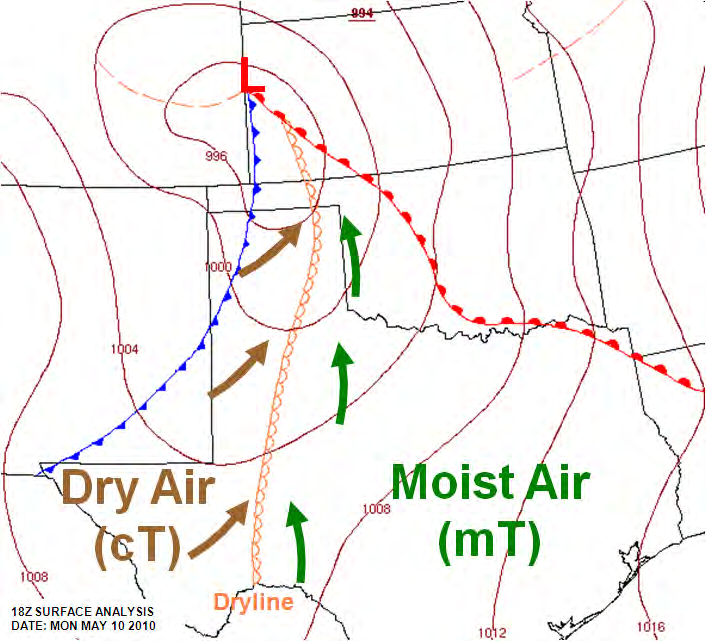
A low-level boundary, hundreds of miles long, between moist and dry air masses. In the United States it typically lies north-south across the southern and central High Plains during the spring and early summer.
Typically advances east in the afternoon and retreats west at night.
Moist side: low clouds and early-morning fog. Dry side: generally clear skies.
Passage: a sharp drop in humidity, clearing skies, and a wind shift from south or southeast to west or southwest.
Pilot hazards
Severe, sometimes tornadic thunderstorms along the dryline or just east of it, especially as it starts moving east.
Blowing dust may follow a daytime passage.
FAA-H-8083-28B, Figure 11-14
Source: AWH 11.5, p. 11-11 · Figure 11-14
The handbook’s own words
“A dryline is a low-level boundary, hundreds of miles long, and separating moist and dry air masses.” AWH 11.5, p. 11-11
“In the United States, it typically lies north-south across the southern and central High Plains during the spring and early summer” AWH 11.5, p. 11-11
“The dryline typically advances eastward during the afternoon and retreats westward at night.” AWH 11.5, p. 11-11
“Low-level clouds and early morning fog often prevail in the moist air, while generally clear skies mark the dry side.” AWH 11.5, p. 11-11
“A typical dryline passage results in a sharp drop in humidity (hence the name), clearing skies, and a wind shift from south or southeasterly to west or southwesterly.” AWH 11.5, p. 11-11
“Severe and sometimes tornadic thunderstorms often develop along a dryline or in the moist air just to the east of it, especially when it begins moving eastward.” AWH 11.5, p. 11-11
“Blowing dust and rising temperatures also may follow, especially if the dryline passes during the daytime.” AWH 11.5, p. 11-11
10 · Squall line
FAA GUIDANCE
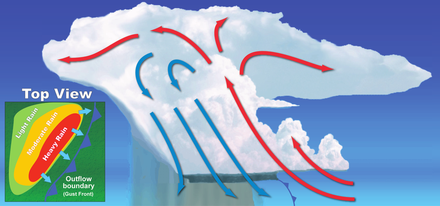
Thunderstorms in a narrow band that can extend laterally for hundreds of miles. It often develops on or ahead of a cold front in moist, unstable air, but it may develop in unstable air far removed from any front.
New cells continually re-form at the leading edge, with rain, and sometimes hail, following behind.
The line can persist for many hours as long as the three ingredients a thunderstorm needs continue to exist.
Pilot hazards
The thunderstorm type that presents the most effective barrier to air traffic: usually too tall to fly over, too dangerous to fly through or under, and difficult to circumnavigate.
About 25 percent of all tornadoes in the United States are spawned by squall lines.
Illustration: NOAA National Weather Service, “Multicellular Line”, Weather Spotter’s Field Guide (June 2011), p. 28. Public domain (U.S. Government work); same artwork as FAA-H-8083-28B Figure 22-4. · Source file · Licence: public domain U.S. Government work
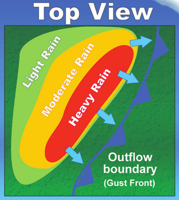
Detail: the “Top View” inset of the same NOAA National Weather Service illustration, cropped by RunupLab and printed larger. Public domain (U.S. Government work). · Source file · Licence: public domain U.S. Government work
Reading the insetTECHNIQUE In its Top View inset, shown enlarged here, the figure labels the line of blue triangles drawn beyond the heavy-rain band “Outflow boundary (Gust Front)”. They mark the edge of this storm's outflow, its gust front: not a cold front, and not the squall-line symbol a surface chart uses (see the legend on the first page).
Source: AWH 22.4, p. 22-4 · Figure: NOAA National Weather Service, Weather Spotter’s Field Guide
The handbook’s own words
“Sometimes thunderstorms will form in a narrow band or squall line that can extend laterally for hundreds of miles.” AWH 22.4, p. 22-4
“Often it develops on or ahead of a cold front in moist, unstable air, but it may develop in unstable air far removed from any front.” AWH 22.4, p. 22-4
“New cells continually re-form at the leading edge of the system with rain, and sometimes hail, following behind.” AWH 22.4, p. 22-4
“The line can persist for many hours (or more) as long as the three necessary ingredients continue to exist” AWH 22.4, p. 22-4
“These squall lines are the thunderstorm type which presents the most effective barrier to air traffic, because the line is usually too tall to fly over, too dangerous to fly through or under, and difficult to circumnavigate.” AWH 22.4, p. 22-4
“About 25 percent of all tornadoes in the United States are spawned by squall lines.” AWH 22.4, p. 22-4
11 · The four fronts, side by side
The same slots for all four fronts — read across a row
FAA GUIDANCE
Cold front
Warm front
Stationary front
Occluded front
What is happening
Cold, dense, stable air advances and replaces warmer air, sliding under it like a snowplow.
Warm air advances and replaces colder air, sliding up over the top of it.
Two air masses of roughly equal force: the boundary between them stays put.
Cold fronts typically move faster than warm fronts, so in time they catch up to a warm front and the two merge.
Speed
25–30 mph; extreme fronts up to 60 mph.
Slow: typically 10–25 mph.
Stationary.
Not specified
Slope
Steep. Warm air is forced upward abruptly.
Typically gentle. Warm air rises gradually along it.
Can vary.
Not specified
Typical weather
Showers and thunderstorms, if the warm air being lifted is unstable.
Widespread layered cloud and precipitation if the warm air is stable; thunderstorms likely in summer.
Typically a mixture of warm-front and cold-front weather.
Warm-front weather, immediately followed by cold-front weather.
Where the weather sits
A narrow band along, or just ahead of, the front, if the warm rising air is unstable.
Widespread, along and ahead of the front, if the warm rising air is stable.
In the warm rising air along the front.
Clouds and precipitation can occur along, ahead of, and behind the surface front.
Pressure trend
Falls quickly, bottoms out at passage, then rises gradually.
Falls until the front passes; then a slight rise, followed by a decrease.
Not specified
Not specified
Exception
If the warm air being overtaken is relatively stable, overcast skies and rain may continue for some distance behind the front.
In summer, thunderstorms are likely.
Not specified
A warm front occlusion lifting unstable air brings more severe weather than a cold front occlusion: embedded thunderstorms, rain and fog are likely.
Main hazard
Squall lines: intense, fast-moving thunderstorms along or ahead of the front.
Poor visibility in light to moderate precipitation, with fog along the frontal boundary.
Not itemized in AWH 11.3.3 — this is not a statement that no hazards exist.
Embedded thunderstorms, rain and fog in a warm front occlusion lifting unstable air.
Near any front
Most icing reports come from near fronts, both above and below the frontal surface.
Above the front: if the warm air is unstable, icing may be sporadic; if it is stable, icing may be continuous over an extended area.
Below the front: freezing rain or freezing drizzle is a favored location for severe clear icing.
Icing in freezing precipitation often extends over a broad area, so a pilot may be unable to escape it by descending to a lower altitude.
Non-convective low-level wind shear (LLWS) is commonly associated with passing frontal systems.
FAA-H-8083-28B, Figure 20-1
Source: AWH 11.3.2, p. 11-6 · 11.3.1, p. 11-5 · 11.3.3, p. 11-7 · 11.3.4, p. 11-8 · 20.3.7, pp. 20-4, 20-5 · 19.2.4.1, p. 19-8 · Figure 20-1
The handbook’s own words
“Most icing reports occur in the vicinity of fronts. This icing can occur both above and below the front” AWH 20.3.7, p. 20-4
“If the warm air is unstable, icing may be sporadic; if it is stable, icing may be continuous over an extended area.” AWH 20.3.7, p. 20-4
“A favored location for severe clear icing is freezing rain and/or freezing drizzle below a front.” AWH 20.3.7, p. 20-5
“Icing in freezing precipitation is especially dangerous because it often extends horizontally over a broad area and a pilot may be unable to escape it by descending to a lower altitude.” AWH 20.3.7, p. 20-5
“Non-convective LLWS is commonly associated with passing frontal systems” AWH 19.2.4.1, p. 19-8
12 · Recall it from memory
Your turn
Fill every box before you look back — a few words or a quick sketch is plenty. Then mark it against the cards and the four-fronts page.
Cold front
Warm front
Stationary front
Occluded front
Air movementsketch and label
Blank — write your answer
Blank — write your answer
Blank — write your answer
Blank — write your answer
Speed and slopeif the handbook gives them
Blank — write your answer
Blank — write your answer
Blank — write your answer
Blank — write your answer
Weather and where it sitsinclude stability
Blank — write your answer
Blank — write your answer
Blank — write your answer
Blank — write your answer
Pressure trendif given
Blank — write your answer
Blank — write your answer
Blank — write your answer
Blank — write your answer
Hazards and exceptionswhat can a simple rule miss?
Blank — write your answer
Blank — write your answer
Blank — write your answer
Blank — write your answer
13 · Apply it
Six situations
Six situations, written by RunupLab. Answer on paper first; the answers and the handbook lines behind them come next.
Temperature and dewpoint drop rapidly, the wind is variable and gusty, and the pressure bottoms out and starts to rise. Which front is passing? Give two clues.
Occlusion A: the air behind the cold front is the coldest. Occlusion B: the air ahead of the warm front is the coldest. Name each, and say what the cold front does.
Each short answer, and the italic note under it, is RunupLab's. The bullets are the handbook's reasoning, in this booklet's short form, and the source line says where to read it.
1 · Read the chartA occluded · B cold · C stationary · D warm
The symbols on a front show its type and point the way it is moving.
The handbook line above says the symbols show a front's type, not which shape is which: the identification comes from the first page's legend, redrawn from the handbook's Figure 27-25. Stationary or occluded? A stationary front's triangles and half-circles sit on opposite sides of the line, an occluded front's on the same side.
Source: AWH 25.2.2.1.3, p. 25-6
The handbook’s own words
“The symbols on the front indicate the type of front and point in the direction toward which the front is moving.” AWH 25.2.2.1.3, p. 25-6
2 · What just passed?A cold front.
During cold front passage the wind is variable and gusty, and the temperature and dewpoint drop rapidly.
A quickly falling pressure bottoms out during frontal passage, then begins a gradual increase.
A warm front passes differently: the wind is also variable and the pressure levels off, but the temperature rises steadily from the inflow of relatively warmer air.
As an occluded front approaches, warm-front weather prevails but is immediately followed by cold-front weather.
The deciding clue is the rapid drop in temperature and dewpoint: at a warm front the temperature rises. The gusty wind is a second clue. Variable wind, and a pressure that stops falling at passage, happen at a warm front too, so they cannot settle it alone. If warm-front weather came just before, the cold-front half of an occluded front is also a fair answer.
Source: AWH 11.3.2, p. 11-6 · 11.3.1, p. 11-5 · 11.3.4, p. 11-8
The handbook’s own words
“During cold front passage, the visibility is poor with winds variable and gusty, and the temperature and dewpoint drop rapidly.” AWH 11.3.2, p. 11-6
“A quickly falling barometric pressure bottoms out during frontal passage, and then begins a gradual increase.” AWH 11.3.2, p. 11-6
“The visibility is generally poor but improves with variable winds.” AWH 11.3.1, p. 11-5
“The temperature rises steadily from the inflow of relatively warmer air.” AWH 11.3.1, p. 11-5
“For the most part, the dewpoint remains steady and the pressure levels off.” AWH 11.3.1, p. 11-5
“As the occluded front approaches, warm front weather prevails but is immediately followed by cold front weather.” AWH 11.3.4, p. 11-8
3 · A front that stays putBecause warm air is still rising along the front.
When two air masses push with roughly equal force, the front between them stays put and can influence the local weather for days.
Clouds and precipitation still form in the warm air rising along the front.
Source: AWH 11.3.3, p. 11-7
The handbook’s own words
“When the forces of two air masses are relatively equal, the boundary or front that separates them remains stationary and influences the local weather for days.” AWH 11.3.3, p. 11-7
“Stationary frontal slope can vary, but clouds and precipitation would still form in the warm rising air along the front” AWH 11.3.3, p. 11-7
4 · Two cold frontsThe stability of the warm air being lifted.
The type of cloud a cold front makes depends on the stability of the warmer air.
Unstable warm air: often a narrow band of showers and thunderstorms along, or just ahead of, the front.
Relatively stable warm air: overcast skies and rain may continue for some distance behind the front.
Source: AWH 11.3.2, p. 11-6
The handbook’s own words
“The type of clouds that form depends on the stability of the warmer air mass.” AWH 11.3.2, p. 11-6
“This often leads to a narrow band of showers and thunderstorms along, or just ahead of, the front if the warm rising air is unstable.” AWH 11.3.2, p. 11-6
“If the warm air being overtaken by the cold front is relatively stable, overcast skies and rain may occur for some distance behind the front.” AWH 11.3.2, p. 11-6
5 · Which occlusion?A: a cold front occlusion — the cold air replaces the cool air and forces the warm front aloft. B: a warm front occlusion — the cold front rides up and over the warm front.
A is a cold front occlusion: the cold front is colder than the air ahead of the warm front, so the cold air replaces the cool air and forces the warm front aloft.
B is a warm front occlusion: the air ahead of the warm front is colder than the air of the cold front, so the cold front rides up and over the warm front.
Source: AWH 11.3.4, p. 11-8
The handbook’s own words
“A cold front occlusion occurs when a fast-moving cold front is colder than the air ahead of the slow-moving warm front.” AWH 11.3.4, p. 11-8
“the cold air replaces the cool air and forces the warm front aloft” AWH 11.3.4, p. 11-8
“A warm front occlusion occurs when the air ahead of the warm front is colder than the air of the cold front.” AWH 11.3.4, p. 11-8
“the cold front rides up and over the warm front” AWH 11.3.4, p. 11-8
6 · Correct the studentBoth are wrong: a stationary front typically brings a mixture of warm- and cold-front weather, and warm air lifted above a front and cooled to saturation below freezing holds supercooled droplets that freeze on impact.
The weather at a stationary front is typically a mixture of the weather found in both warm and cold fronts.
Most icing reports come from near fronts, and the icing can be above or below the front.
For significant icing above a front, the warm air must be lifted and cooled to saturation below freezing; it then holds supercooled water droplets, which freeze on impact with an aircraft.
Below the front: rain forms above the frontal surface at temperatures warmer than freezing, falls through below-freezing air, becomes supercooled and freezes on impact with an aircraft. Freezing rain or drizzle below a front is a favored location for severe clear icing.
“Not itemized” is this booklet's label, not the handbook's: it means the cited section lists no hazards — never that there are none.
Source: AWH 11.3.3, p. 11-7 · 20.3.7, pp. 20-4, 20-5
The handbook’s own words
“The weather associated with a stationary front is typically a mixture that can be found in both warm and cold fronts.” AWH 11.3.3, p. 11-7
“Most icing reports occur in the vicinity of fronts. This icing can occur both above and below the front” AWH 20.3.7, p. 20-4
“For significant icing to occur above the front, the warm air must be lifted and cooled to saturation at temperatures below zero, making it contain supercooled water droplets.” AWH 20.3.7, p. 20-4
“The supercooled water droplets freeze on impact with an aircraft.” AWH 20.3.7, p. 20-4
“A favored location for severe clear icing is freezing rain and/or freezing drizzle below a front.” AWH 20.3.7, p. 20-5
“Rain forms above the frontal surface at temperatures warmer than freezing.” AWH 20.3.7, p. 20-5
“Subsequently, it falls through air at temperatures below freezing and becomes supercooled.” AWH 20.3.7, p. 20-5
“The SLDs freeze on impact with an aircraft.” AWH 20.3.7, p. 20-5
15 · Sources
Where every line and figure comes from
Handbook
FAA-H-8083-28B, Aviation Weather Handbook
Edition
2026 edition, signed and published April 2, 2026 (the handbook's preface)
Retrieved
2026-09-01, from https://www.faa.gov/sites/faa.gov/files/FAA-H-8083-28B.pdf
Frozen copy
PDF sha256 2a87e4a5613e2a8e… · text sha256 192a2b9042d73772…
Text extraction
pdftotext 25.07.0 (poppler), -layout, whole book
What “checked” means here
Every handbook sentence behind a line in this booklet is quoted in its data file and machine-checked: word for word in the frozen handbook, on the printed page the card's source line names, and with no number in our wording that the quote does not contain. The short wording you read is RunupLab's compression of those quotes. No machine can prove a compression faithful — a CFI review of the wording is still owed. The handbook is FAA guidance, not regulation.
Figures
From FAA-H-8083-28B, each extracted as the bitmap embedded in the frozen PDF — PDF page (printed page):
Figure 10-2. Magnitude of Pressure Gradient Force— p. 118 (p. 10-3)
Figure 10-11. Surface Wind Flow— p. 123 (p. 10-8)
Figure 12-5. Frictional Effects— p. 151 (p. 12-7)
Figure 11-1. Air Mass Classification— p. 136 (p. 11-3), cropped to the globe of source regions (its table is dropped)
Figure 11-2. Air Mass Modification—Warm, Moist Air Mass Moving Over a Cold Surface— p. 136 (p. 11-3)
Figure 11-3. Lake Effect— p. 137 (p. 11-4)
Figure 11-6. Cold Front— p. 140 (p. 11-7)
Figure 11-7. Stationary Front— p. 140 (p. 11-7)
Figure 11-8. Occluded Front— p. 141 (p. 11-8)
Figure 11-9. Wave Cyclone Model—Stage 1— p. 142 (p. 11-9)
Figure 11-10. Wave Cyclone Model—Stage 2— p. 142 (p. 11-9)
Figure 11-11. Wave Cyclone Model—Stage 3— p. 143 (p. 11-10)
Figure 11-12. Wave Cyclone Model—Stage 4— p. 143 (p. 11-10)
Figure 11-13. Wave Cyclone Model—Stage 5— p. 143 (p. 11-10)
Figure 11-14. Dryline Example— p. 144 (p. 11-11)
Figure 20-1. Icing with Fronts— p. 247 (p. 20-5)
Chart-symbol legend and the symbol quiz— Redrawn from FAA-H-8083-28B, Figure 27-25, by RunupLab
Pictures from outside the handbook
Two pictures come from outside the handbook, with the owner's approval; each prints its credit and licence under it and here. CC BY-SA 4.0 covers the warm-front picture and RunupLab's crop of it, not the rest of this booklet. A credit says where a picture came from; it does not mean its author or publisher reviewed or endorses this booklet.
Cross section through a warm front (cropped).“Cross section through a warm front (cropped)” by Kh1604, Wikimedia Commons (a crop of Kh1604’s “Cross section through a cold front and warm front”), CC BY-SA 4.0 (creativecommons.org/licenses/by-sa/4.0). Km scale and distance bar removed by RunupLab; this cropped version is licensed CC BY-SA 4.0. · Retrieved 2026-09-23 · cropped from the frozen original, sha256 0aefc575fc7a…https://commons.wikimedia.org/wiki/File:Cross_section_through_a_warm_front_(cropped).jpg · https://creativecommons.org/licenses/by-sa/4.0/
Multicellular Line (Weather Spotter’s Field Guide, p. 28).Illustration: NOAA National Weather Service, “Multicellular Line”, Weather Spotter’s Field Guide (June 2011), p. 28. Public domain (U.S. Government work); same artwork as FAA-H-8083-28B Figure 22-4. · Retrieved 2026-09-23 · PDF p. 30 (printed p. 28), extracted as embeddedhttps://www.weather.gov/media/bis/Weather_Spotter_Field_Guide.pdf · https://www.weather.gov/disclaimer
Multicellular Line — its Top View inset (detail).Detail: the “Top View” inset of the same NOAA National Weather Service illustration, cropped by RunupLab and printed larger. Public domain (U.S. Government work).
ACS elements covered (FAA-S-ACS-6C)
PA.I.C.K3e — e. Weather system formation, including air masses and fronts (covered here: air masses, fronts, the wave cyclone)
PA.I.C.K3i — i. Icing and freezing level information (covered here: icing near fronts only)
Written by RunupLab
RunupLab wrote the practice questions, their short answers, the italic notes under the answers, the recall prompts, the sheet subtitles, the notes marked TECHNIQUE, and the reading notes on the first page. Those are our words, not the handbook's. The reasoning bullets under each answer are the handbook's, in this booklet's short form — the same compression every card uses.
Badges.REGULATION quoted from 14 or 49 CFR.FAA GUIDANCE quoted from the AIM, an AC, or an FAA handbook — advice, not law.POH/AFM your aircraft’s own records govern.TECHNIQUE our voice — how to think about it.Text outside quotation marks is ours, whatever badge sits nearby.
This is a study aid. Real fronts do not read the textbook. It does not replace a weather briefing, the handbook, or your CFI. Sources, figure credits and what “checked” means here are in the Sources section.
Find your weak areas — the free 24-question Readiness Test, scored by knowledge area.
Create a free account for the full bank: 3,180 verified questions with the FAA source on every answer, a timed practice exam, and a missed-questions drill.
The Private Pilot Quick-Review Study Guide covers this in the matching chapter, with the same sources. It is in CFI review and not on sale yet; the guide page has the list for launch notes.
Launch notes
One email when the study guide ships, and when a new sheet or sim lands. No drip, no spam.
No spam — launch notes and new sims only. Unsubscribe anytime.
.jpg)